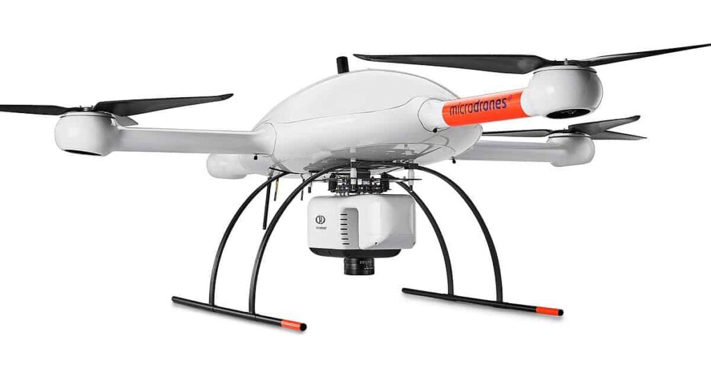
Kuker-Ranken, a leading provider of architectural, engineering, construction, survey equipment and supplies since 1928, joined the network of distributors for Microdrones and will supply drone surveying equipment to their customers throughout the US Pacific Northwest Region.
By adding drone LiDAR and mapping solutions from Microdrones to their extensive equipment portfolio, Kuker-Ranken now offers a complete mapping solution composed of drone surveying equipment and data processing modules fully adapted to that survey equipment. It includes the drone, the payload, and Microdrones proprietary mdCockpit mission planning and control software.
“We have been providing unmanned equipment to our customers for years, and as the technology shifts, we’ve recognized the need to create a separate division within Kuker-Ranken to best support robotics as a solution for our customers, whether air, sea, or land-focused. Whether it’s flying, or terrestrial robotics supporting scanning equipment, we are deeply focused on providing these solutions and training to our customer base,” said Robert Lycke, president of Kuker-Ranken.
“We couldn’t be more excited to work with the team at Kuker-Ranken,” said Aaron Beach, the Northwest regional manager for Microdrones who helped facilitate the new partnership. “They have been leaders in the Pacific Northwest GIS supply industry for nearly a century. Between those deep roots, and the leadership of Douglas Spotted Eagle, who is a UAS industry pioneer, we believe we’ve found a fantastic partner in KR.”
Kuker-Ranken will be displaying their new Microdrones mdLiDAR1000HR at the 2021 World of Concrete June 8 – 10 at the Las Vegas Convention Center. World of Concrete is the industry’s ONLY annual international event dedicated to the commercial concrete and masonry construction industries. Featuring indoor and outdoor exhibits with the industry’s leading suppliers showcasing innovative products and technologies, exciting demonstrations and competitions, and a world-class education program. CLICK HERE for more information and to register online- there will not be onsite registration due to Covid safety protocols.
“Kuker-Ranken prides itself on offering the highest quality products and supplies to our customers,” says Douglas Spotted Eagle, Chief Strategy Officer (CSO) at Kuker-Ranken Inc. “The UAV surveying systems from Microdrones will enable our customers to add one of the best drone surveying systems to their toolbox.”
“We’re excited to be in-person at a trade show and able to let people see the unmanned surveying equipment up close and personal,” said Lycke. “We’re looking forward to speaking with anyone involved in planning, developing, operating, or post-processing construction data or projects.”
About Kuker-Ranken
For more than 90 years Kuker-Ranken has served Surveyors, Architects, General Contractors and Design Professionals in the Pacific Northwest. KR opened its doors in 1928 and now has expanded to six locations in Seattle, Tacoma, Portland, Salt Lake City, Las Vegas, and St. George to better serve their customers. They continually train their personnel and only provide the best in quality products and customer service.
Kuker-Ranken still manufactures their World Famous Kuker-Ranken hand level that started the company in 1928 as well as offer instrument sales and service on the most current equipment. KR is the Authorized Leica GeoSystems (LGS) dealer for Washington, Oregon, Idaho, Nevada, Utah, and Northern California.
About Microdrones
Microdrones grew out of the collaboration between the German inventor of the world’s first commercial quadcopter and a determined surveying payload and software developer in North America. The result is a global aerial mapping technology company that delivers complete and reliable mapping systems specifically developed for the surveying, mining, construction, oil & gas, and precision agriculture industries.
Microdrones Integrated Systems are industrial tools addressing specific complex mapping challenges for professional customers, relying on a fully integrated geospatial workflow that enables cutting-edge software technology from Microdrones to transform raw data collected in the field by Microdrones survey equipment into valuable high-quality survey grade data. Microdrones is widely recognized for its LiDAR technology leadership.
Microdrones has engineering centers and manufacturing facilities in Germany, Canada, France, China, and the United States, as well as a sales, support and distribution network spanning six continents.
Microdrones serves markets around the globe. To learn more about Microdrones, visit www.microdrones.com or follow @Microdrones on Facebook, LinkedIn, or Twitter.


More Stories
Click Shield from MIKROE simplifies integration of Arduino Portenta with over 1600 Click boards
Optimizing Mid-Power Silicon MOSFETs for Automotive Applications
Paolo Pininfarina named the 2024 Laureate of The American Prize for Design