


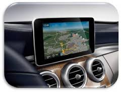
From now on, companies and start-ups working on autonomous driving have the opportunity to use a free specification of the high-definition lane model. It makes it possible to display highly accurate lane data needed for autonomous driving technologies.
The specification is part of a common industry standard and was previously only available to members of the association. The NDS Association, an industrial consortium of automobile manufacturers such as BMW, Daimler, Hyundai Motor, Volkswagen and Volvo Car, provides the specification as the download package “NDS Open Lane Model” on the website http://www.openlanemodel.org. “With the release of the NDS Open Lane Model, NDS wants to enable all parties working on autonomous driving technologies to benefit from the work done in the NDS Association. They will benefit from a format which is widely used in cars on the road already,” explained Dr. V. Sasse, VP of NavInfo, Chairman of NDS and Speaker of Open Auto Drive Forum.
Open Lane Model: improves localization and path planning on routes
The Open Lane Model (OLM) is more precise than conventional models: it stores lane topology and high-precision geometries of up to 1-cm resolutions. Besides being able to assign standard attributes, such as speed limits, to lanes with high accuracy, the model shows boundaries, such as walls or tubes and colored lane markings. Furthermore, complex intersections are described by a sophisticated connectivity model. With the support of camera- and LiDAR-based systems, the software faces two challenges of autonomous driving:
Upgrade to the full NDS standard’s lane model
OLM is part of the NDS standard. With the download, companies receive the license to integrate the model into their technologies for pushing their concepts of autonomous driving. It is possible to enrich the maps with users’ own data or to obtain real maps offered by NDS map suppliers. The free version does not allow commercial use. An upgrade to the full NDS standard is possible at any time when companies join the NDS Association with their business cases. The full NDS lane model offers advanced features, such as lane-level traffic, lane-level parking and more optimizations that enable compact and highly efficient maps for autonomous driving.
About NDS
NDS is a registered association with the vision of providing a leading worldwide map standard for automotive-grade use. It consists of car manufacturers, application/compiler developers, map and service providers. For more information and members:

More Stories
Avery Dennison PSA tapes support rapid evolution of EV batteries
Sensor Fusion and the Next Generation of Autonomous Driving Systems
Automotive Industries (AI) Newsletter April 2025